
Projects on Geospatial Applications: 3D Terrain Model Project
Generation of 3D Terrain Model for all the 33 districts using High resolution satellite , Survey of India map and Elevation data for Police and Civil authorities. The 3 district wise models were provided to Assam Police Department for their operational requirement.
Application of 3D Terrain Model: Education GIS project
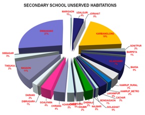
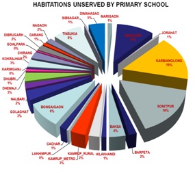
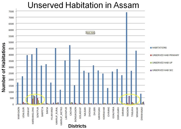
NECTAR has conducted neighbourhood Mapping & GIS analysis of different categories of schools (Primary, Upper Primary, secondary & Senior secondary) using 3D Digital Terrain Model , the state’s Education Department( Sarba Siksha Abhiyan ) in establishing new Schools in areas of un-served population based on norms of Government of India Right To Education program.
For the state of Assam, mapping of 66,115 schools in different categories along with 81,240 habitations were analyzed on 3D Terrain Models using GIS technology. Mapping of Schools integrating with habitation layers was done for neighbourhood analysis and the analysis was provided to SSA of Assam for identification of areas which need set up new schools. The above analysis envisages the state education department for establishing a Modern Education GIS Lab at Guwahati for development of Child Tracking system along with setting up few SMART SCHOOLs based on mesh net communication network.
High Precision Mapping using Drones : Brahmaputra River Embankment Mapping
Aerial Imaging of 50sqkm area for Embankment and Erosion study on banks of Brahmaputra River as pilot project which has Application in flood plain mapping for Water Resources Department, Government of Assam
With the innovation of UAV/Drone technology, though it was already active in military surveillance since a decade, its mapping applications can be explored over an Area of Interest. The ultra high resolution imaging capabilities through cameras mounted on board are key feature of this technology which can be processed into . The products generated from this technology viz. High resolution land use information, centimetre (cm) level 3D terrain elevation data, coupled with population dataset can provide a rapid estimate of the population affected before & after the floods and can be useful in humanitarian aid. Flood mitigation in vast basins like the Brahmaputra requires an integrated approach involving a combination of both structural and non-structural measures to be taken making best use of the information extracted from UAV/Drones & advanced technologies of remote sensing and GIS.
A case study on generation of Digital Surface Model & Land Use data from Drones acquired image over Brahmaputra plains has been accomplished to show casing the visualization of water related disaster and its mitigation. Also 3D GIS analysis over DSM of the area has been performed to help the State Government authorities for mitigation of flood related disaster. It is also realized that periodic imaging through small Drone (Micro-UAV) platform over the area could be very much useful to monitor and record high quality information for modelling water in the river and its flood plain area. This could also assist the authorities to analyze the pattern of erosion and river sedimentation of Brahmaputra river and suitable preventive measures viz. location & size of protective embankments to be constructed along the river banks to prevent loss of human lives, their households and agricultural crops. Around 4500 sq km of area on both flanks of the Brahmaputra River is under consideration for imaging through drones, as a result of this case study.
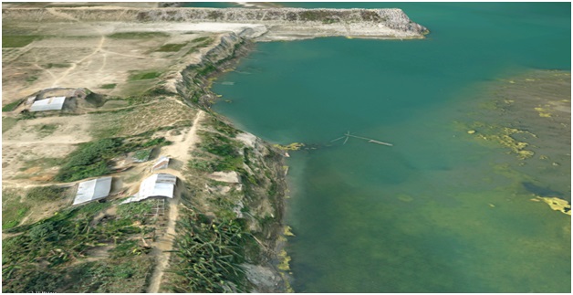
Fig : 3D mapping of protective Embankments and Erosion along Brahmaputra River bank.
Projects on Communication Activities:
- SDR Project: NECTAR has established a radio communication network between various remote districts with Police HQ. Despite Assam Police has wide area of police network over different types of terrain conditions Viz. plane, hilly and mountainous areas which pose a great challenge to establish a clear line of sight, NECTAR was able to provide a wireless network. The state of Assam is extended in large areas divided by Gigantic Brahmaputra river, survey and feasibility of line of sight is was done. In the state, 29 Software Defined Radios(SDR) have been installed to inter connect police stations with headquarters.
- Mesh Network for CCTV based surveillance project in Guwahati: On the request of the Assam police a demonstrator mesh network project was planned in order to showcase the possibility of having a wireless system for CCTV surveillance. Earlier they had, for some areas, established a network which was connected on an exposed cable. There were problems of regular breakdown or issues of vandalism. Based on the request, mesh networks were established at a number of locations with fixed lens cameras as well as point, tilt and zoom cameras. The average through put in the system is 150- 180 mbps, providing sufficient band width to have streaming data with a clear picture in the control room operational by a team trained by NECTAR with a capacity to point, tilt or zoom the cameras according to their requirements. On the request of the Guwahati police back up has been provided in the control room, along with air conditioning, because large number of equipments have been installed in a small space. This has been handed over to Assam Police. Ample data storage has been provided for control room for revisiting the footage for analysis.
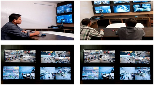
Fig. MESHNET CCTV Surveillance in Assam
The facility has following specifications:
- CCTV network for 09 Locations in Guwahati City for Assam State Police
- 36 IP based surveillance HD cameras with PTZ
- facility capable of 24X7 Day & Night Vision.
- Set Up Modern Control Room with 06 Display units & storage up to 30days data backup.
- Training and capacity Building by NECTAR
3. Wireless communication network for CCTNS project as Proof Of Concept for Assam Police: A network consists of a number of wireless nodes, with simplest connection is the point-to-point link. These links can be used to extend a network for wider area coverage . The network would be established by Installation of 15m to 21m Mast (LOS based ) mounted with RF Transponders Low/Medium/High power) capable of data communication with high bandwidth ( 150-200mbps) over unlicensed spectrum.
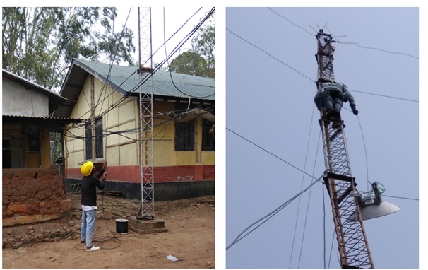
03 (Three) police station (unconnected sites) were connected by the above technology for Assam Police with data speed up to 200 mbps.
पृष्ठ आखरी अपडेट : 06-03-2025 - 23:30