
Projects on Geospatial Applications: 3D Terrain Model Project
3D Terrain Model, is an integrated digital product created based on technology of 3D GIS integration of different scales of Survey of India Maps, high resolution satellite/aerial imagery and digital elevation data which have a common Geographical coordinate System was generated for 15 out of 16 districts of Arunachal Pradesh comprising of 74,476 sq km geographical area. The above GIS products are useful for all levels of planning & operations showing from house to Global level 3D visualization. The Model is a Digital standalone Product which enables to carrying out 2D & 3D GIS analysis necessary for security forces and Government developmental planners.The model was created with a lot of challenge of cloud coverage in the satellite data.
The Geo-referencing accuracy was also an issue while processing and generating the satellite scenes due to its thick forest canopy. Control points of Survey of India Topo sheets were used in the satellite data for geo-referencing, and most of the areas were controlled by onboard satellite GPS coordinates provided by satellite data kit and the highly mathematical transformation algorithm using the RPC data. Another challenge was received during the ortho-rectification process of 3D terrain building that the unavailability of authenticated elevation data pertaining to international border areas from Survey of India due to security reasons and thereby the model was built by the use of free elevation data availed from various sources. However , the district level model is capable of basic 3D GIS analysis which all required by Police Department. It can provide huge operational benefits to the police departments in field planning and reconnaissance purpose.
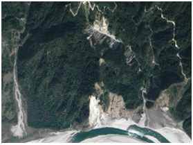
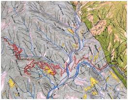
Fig: 3D Terrain Model of Lohit District of Arunachal with Survey of India Topo Sheets and High resolution satellite data
Projects on Communication Activities: SDR Project A Software-Defined Radio (SDR) refers to the technology wherein software modules running on a generic hardware platform consisting of DSPs (Digital Signal Processors) and general purpose microprocessors are used to implement radio functions such as generation of transmitted signal (modulation) at transmitter and tuning/detection of received radio signal (demodulation) at receiver. The topography of Arunachal Pradesh is characterized by an undulating hilly terrain, towering hill slopes, enthralling river valleys and imposing peaks. For a very long time the region remained with very poor telecommunication connectivity facility due to its location in difficult terrain with impenetrable vegetation. Therefore wireless and digital telecommunication facility through SDRs would be possible in the state especially interconnectivity with police stations.
Projects on Communication Activities: SDR Project
A Software-Defined Radio (SDR) refers to the technology wherein software modules running on a generic hardware platform consisting of DSPs (Digital Signal Processors) and general purpose microprocessors are used to implement radio functions such as generation of transmitted signal (modulation) at transmitter and tuning/detection of received radio signal (demodulation) at receiver.
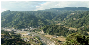
The topography of Arunachal Pradesh is characterized by an undulating hilly terrain, towering hill slopes, enthralling river valleys and imposing peaks. For a very long time the region remained with very poor telecommunication connectivity facility due to its location in difficult terrain with impenetrable vegetation. Therefore wireless and digital telecommunication facility through SDRs would be possible in the state especially interconnectivity with police stations.
The network of 78 static SDRs and 12 mobile SDRs/man packs for voice and data transfer with the headquarters as well as between police stations without any repeaters has been set up. NECTAR has installed a fail-safe communication network for the State Police Department. 70 police stations are connected through software defined radio (SDR) system, out of which 44 SDR sets are installed in the police stations in eastern and western ranges, while the Central range police stations got the remaining, linking the police stations with the headquarter. In addition to this over 12 radios have been installed in the police vehicles for effective mobile communication.
This network allows voice, data transfer which includes Photograph, PDF, Word, Excel and many other types of file format etc. and broadcast facilities. These sets transfer photographs error free and in case of any error, will automatically re-transfer the packet without error.
There is seamless network connectivity from Zemithang on the Chinese border to Vijay Nagar on the Burmese border around an aerial distance of over 500 km.
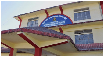
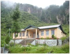
Fig: Difficult Terrain Conditions and Police Station of Arunachal Pradesh connected via SDR projects.
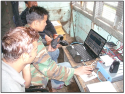
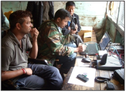
Fig. Training of SDR at Zimithang, Arunachal Pradesh
पृष्ठ आखरी अपडेट : 06-03-2025 - 23:30